How Self-Driving Cars Use Danger Maps to Drive Safer
This patent describes how vehicles can use a 'danger map' of known hazardous locations to plan safer routes and automatically adjust their driving behavior, like speed or following distance, when approaching risky areas.
Original patent title: “System and method for determining navigational hazards”
This patent describes how vehicles can use a 'danger map' of known hazardous locations to plan safer routes and automatically adjust their driving behavior, like speed or following distance, when approaching risky areas. Owned by Faraday and Future with 24 claims and 38 forward citations, and it is expected to expire in 2037.
Coverage
What does this patent actually cover?
This system helps a vehicle drive more safely by first receiving a 'danger map' (ClaimclaimA numbered sentence at the end of a patent that legally defines what the inventor owns. The most important section.Read more → 1). This map shows different locations, each with a 'danger value' based on past events like accidents or near misses collected by other vehicles (Claim 1, 6). The vehicle then uses this map to determine a route from its starting point to its destination, choosing paths with lower danger values (Claim 1). While driving, if the vehicle approaches a location whose danger value exceeds a set limit, it automatically modifies its operation (Claim 2). This modification can include reducing its top speed, increasing its following distance from other cars, or even changing its lane-changing rules (Claim 4, 5). For example, if the danger map indicates a specific highway exit has a high danger value due to frequent emergency braking, a self-driving car might automatically slow down and increase its following distance as it approaches that exit.
The gap
What does this patent NOT cover?
- Does not cover systems that only detect real-time hazards using on-board sensors without relying on a pre-received, location-specific 'danger map' (ClaimclaimA numbered sentence at the end of a patent that legally defines what the inventor owns. The most important section.Read more → 1).
- Does not cover systems that only warn a human driver about hazards without automatically modifying the vehicle's driving behavior (ClaimclaimA numbered sentence at the end of a patent that legally defines what the inventor owns. The most important section.Read more → 2).
- Does not cover systems where the vehicle's operation is modified based on current traffic conditions alone, rather than a pre-determined danger value associated with a specific location (ClaimclaimA numbered sentence at the end of a patent that legally defines what the inventor owns. The most important section.Read more → 1).
- Does not cover systems that only suggest an alternative route to a human driver, without the vehicle itself determining and potentially adjusting its own route based on danger values (ClaimclaimA numbered sentence at the end of a patent that legally defines what the inventor owns. The most important section.Read more → 1, 9).
- Does not cover systems where the 'danger map' is exclusively built by the vehicle's own sensors without receiving data from other sources or vehicles (ClaimclaimA numbered sentence at the end of a patent that legally defines what the inventor owns. The most important section.Read more → 1, 6).
These exclusions are unique to PatentBrief — derived from the actual claim language, not patent-office boilerplate.
Key facts
What made this novel
The core innovation is combining a pre-existing, location-specific 'danger map' with dynamic, automated adjustments to vehicle operation. This allows a vehicle to anticipate potential hazards at specific points on its route based on historical data, rather than just reacting to immediate sensor inputs, enabling proactive safety measures.
The Patent Drawing
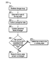
Schematic visualization of the patent's claim structure. Hand-drawn diagrams in progress for each landmark patent.
Where you've seen this
Real-world examples
Autonomous driving systems (e.g., Waymo, Cruise)
Advanced Driver-Assistance Systems (ADAS) that integrate map data for predictive speed control
Navigation apps that factor historical accident data into route suggestions
High-definition mapping services used by self-driving cars
Why it matters
The bigger picture
This patent addresses a critical challenge for autonomous vehicles: how to anticipate and react to hazards that aren't immediately visible to on-board sensors. By using shared, location-based danger data, vehicles can proactively adjust their driving, potentially preventing accidents and improving safety. This approach helps autonomous systems move beyond reactive driving to more predictive and cautious navigation, which is essential for public trust and widespread adoption of self-driving technology.
Filed
August 16, 2017
Market context
Who's building on this
Companies in this space
Faraday and Future Inc., the original assigneeassigneeThe entity that owns the patent — usually the inventor's employer or a company.Read more →, is an electric vehicle company that continues to develop autonomous driving capabilities. Other major players in the autonomous vehicle space, such as Waymo, Cruise, Mobileye, and Tesla, are actively researching and implementing systems that use various forms of collective data and predictive mapping to enhance vehicle safety and navigation. Traditional automakers like General Motors, Ford, and Mercedes-Benz are also investing heavily in similar technologies for their ADAS and future self-driving car fleets.
Market impact
This patent contributes to the ongoing evolution of autonomous driving by emphasizing the value of shared, location-specific hazard data. It highlights a shift towards more proactive safety systems that leverage collective intelligence rather than relying solely on individual vehicle sensors. This approach can influence the development of industry standards for data sharing among vehicles and infrastructure, potentially leading to safer and more reliable autonomous driving experiences across the market.
Claim 1 — Plain English
What this patent covers
This system helps a vehicle drive more safely by first receiving a 'danger map' (Claim 1). This map shows different locations, each with a 'danger value' based on past events like accidents or near misses collected by other vehicles (Claim 1, 6). The vehicle then uses this map to determine a route from its starting point to its destination, choosing paths with lower danger values (Claim 1). While driving, if the vehicle approaches a location whose danger value exceeds a set limit, it automatically modifies its operation (Claim 2). This modification can include reducing its top speed, increasing its following distance from other cars, or even changing its lane-changing rules (Claim 4, 5). For example, if the danger map indicates a specific highway exit has a high danger value due to frequent emergency braking, a self-driving car might automatically slow down and increase its following distance as it approaches that exit.
The clever bit
The core innovation is combining a pre-existing, location-specific 'danger map' with dynamic, automated adjustments to vehicle operation. This allows a vehicle to anticipate potential hazards at specific points on its route based on historical data, rather than just reacting to immediate sensor inputs, enabling proactive safety measures.
What it does not cover
- Does not cover systems that only detect real-time hazards using on-board sensors without relying on a pre-received, location-specific 'danger map' (Claim 1).
- Does not cover systems that only warn a human driver about hazards without automatically modifying the vehicle's driving behavior (Claim 2).
- Does not cover systems where the vehicle's operation is modified based on current traffic conditions alone, rather than a pre-determined danger value associated with a specific location (Claim 1).
- Does not cover systems that only suggest an alternative route to a human driver, without the vehicle itself determining and potentially adjusting its own route based on danger values (Claim 1, 9).
- Does not cover systems where the 'danger map' is exclusively built by the vehicle's own sensors without receiving data from other sources or vehicles (Claim 1, 6).
Patent timeline
Application submitted to the patent office
Patent enters public domain
PatentBrief Score
Impact Score
Moderate
Citation count
32/40
Moderately cited
Claim breadth
16/20
Broad claimsclaimsThe numbered statements at the end of a patent that legally define what the inventor owns.Read more →
Recency
0/20
Older than 20 years
Assignee scale
0/20
Independent or smaller assigneeassigneeThe entity that owns the patent — usually the inventor's employer or a company.Read more →
PatentBrief Impact Score — based on citation count, claim breadth, recency, and assignee scale. Not a legal assessment.
Heuristic Value Estimate
What this patent might be worth
$88K – $281K
Midpoint $176K · 10.9 yr remaining · industry ×0.9
Heuristic only — blends forward/backward citation counts, claim scope, time remaining, litigation history, and CPC-derived industry baseline. Real valuations need a professional appraisal.
Claim text not yet imported for this patent
The original legal language
Original claims
24 claims as filed with the patent office.
Concepts involved
Citations
Patent lineage
Cite this patent
Jian, Y. How Self-Driving Cars Use Danger Maps to Drive Safer (U.S. Patent No. 20,180,239,359). U.S. Patent and Trademark Office. https://patentbrief.org/patent/us/20180239359/system-and-method-for-determining-navigational-hazards
Auto-generated from the patent record. Double-check author order and the issue date against the official USPTO document before submitting.
Embed
Add this patent to your site
Drop this plain-English patent card into any blog post or article — free, no signup. It always links back to the full breakdown here.
<div data-patentlens-widget data-patent-number="US20180239359"></div>
<script src="https://patentbrief.org/embed.js" async></script>
Stay in the loop
Get a weekly digest of new patents.
One email per week. No spam. Unsubscribe anytime.
Keep exploring
Related patents you should know
US 4683195 · 1987
How to Make Billions of Copies of a DNA Segment
This patent describes the Polymerase Chain Reaction (PCR), a method to rapidly create many copies of a specific piece of DNA or RNA, enabling its detection and analysis.
Cetus Corp
US 8697359 · 2014
How to Edit Genes in Human Cells Using an Engineered CRISPR System
This patent describes an engineered CRISPR-Cas9 system for precisely cutting DNA in eukaryotic cells to change how genes work, opening the door for gene editing in complex organisms.
Massachusetts Institute of Technology
US 7657849 · 2010
How the iPhone's Slide-to-Unlock Gesture Works
Apple's 2010 patent describes unlocking a device by dragging a specific graphical image across the touchscreen along a predefined path, a gesture that became iconic with the original iPhone.
Apple Inc
US 4733665 · 1988
How Doctors Implant a Permanent Stent Using a Balloon
This patent describes the method for placing a permanent, expandable wire mesh tube inside a blood vessel or other body tube using a balloon-tipped catheter to widen it and keep it open.
Expandable Grafts Partnership
US 4965188 · 1990
How to Make Many Copies of a DNA Piece with Heat
This patent describes the Polymerase Chain Reaction (PCR) method, a technique to make millions of copies of a specific DNA segment using a heat-resistant enzyme and repeated temperature changes.
Cetus Corp
US 4235871 · 1980
How to Encapsulate Active Materials in Lipid Bubbles Efficiently
This patent describes a method for trapping biologically active substances inside tiny, multi-layered fat bubbles called liposomes, using a specific water-in-oil emulsion and gel-forming process to improve how much material gets captured.
Individual
Semantically similar
You might also find these interesting
US 10733420 · 2020 · GM Global Technology Operations
How Self-Driving Cars Find Clear Paths Between Objects
US 20220161815 · Intel
How Autonomous Cars Process Sensor Data for Driving
US 9562773 · 2017 · Aurora Flight Sciences
Drone Navigation Using Cameras and Echolocation
US 11702088 · 2023 · Magna Electronics
How Car Safety Systems Turn Off When Sensors Disagree
More to explore
More in Energy & Clean Tech
US RE49155 · 2022 · Halliburton Energy Services Inc
Electric or Natural Gas Blending and Pumping for Oil Wells
US 11436484 · 2022 · Nvidia Corp
Nvidia's Method for Training Self-Driving Car AI in Simulations
US 11840398 · 2023 · Titan Trailers Inc
How Titan Trailers Builds Stronger, Smoother Cargo Containers
US 2708656 · 1955
How the First Nuclear Reactor Works
New to patents?
Common Questions
Frequently Asked Questions
What does How Self-Driving Cars Use Danger Maps to Drive Safer cover?
This patent describes how vehicles can use a 'danger map' of known hazardous locations to plan safer routes and automatically adjust their driving behavior, like speed or following distance, when approaching risky areas.
Who owns patent US 20180239359?
This patent is owned by Faraday and Future.
When does this patent expire?
This patent is expected to expire on August 16, 2037, when the invention enters the public domain.
What is patent US 20180239359 cited by?
This patent has been cited by 38 later patents that build on its ideas.
What problem does this patent solve?
This patent addresses a critical challenge for autonomous vehicles: how to anticipate and react to hazards that aren't immediately visible to on-board sensors. By using shared, location-based danger data, vehicles can proactively adjust their driving, potentially preventing accidents and improving safety. This approach helps autonomous systems move beyond reactive driving to more predictive and cautious navigation, which is essential for public trust and widespread adoption of self-driving technology.
What does this patent NOT cover?
Does not cover systems that only detect real-time hazards using on-board sensors without relying on a pre-received, location-specific 'danger map' (Claim 1).
Patent monitoring